| Route description: Beinn Chabhair, from Inverarnan Munros included on this walk: Beinn Chabhair Time taken: 6.5 hours Distance: 14km Ascent: 1010m |
The weather all week had been fantastic and I had managed a solo walk up A'Bhuidheanach Bheag earlier on the Wednesday in excellent alpine conditions (no report). It was now Friday and I had the opportunity to get out again, this time with a couple of friends from work. As we all work shifts the stars do not often align ! Although the forecast from MWIS was not the guaranteed sunshine and clear summits it had been earlier in the week, incredibly, there was still a chance almost a week later that we could be met with amazing conditions if the top of the cloud layer could just stay below 900m. We had decided that Beinn Chabhair would be a good choice for us, a relatively quick summit and not too far to travel to the start point at the well known Drovers Inn at Inverarnan. On the drive through it was hard to imagine we would see any sun today, low cloud and drizzle enveloped us for the whole journey. We arrived in good time and were sonn suited and booted and on our way for 08.45.
The walk begins with a stroll, following the pavement along the A82 to the turning for Beinglas Farm Campsite. Here we walked through the field, following the river and skirted our way around the campsite itself. The ascent starts from the back of the campsite, and it's a bloody steep one, following the stony, loose path up towards the impressive Beinglas Falls.
The walk begins with a stroll, following the pavement along the A82 to the turning for Beinglas Farm Campsite. Here we walked through the field, following the river and skirted our way around the campsite itself. The ascent starts from the back of the campsite, and it's a bloody steep one, following the stony, loose path up towards the impressive Beinglas Falls.
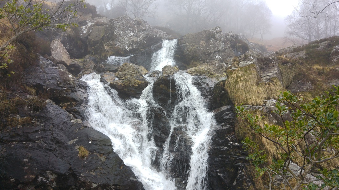
One of the many waterfalls on the ascent
It was hard going, especially it being my second walk in 3 days and my companions first walk this year. I had managed to leave my bottle of juice on the kitchen worktop and most graciously, Wullie had given me the choice of one of his two bottles, either his litre of water or the litre of ready made Robinson's 'Apple & Pear', I chose the juice.....which as the day wore on became apparent I was supposed to take the water lol. The Robinsons was delicious, I'd thoroughly recommend it !! In all seriousness, I was extremely grateful as we were only half an hour in and already it was thirsty work getting up this hill. On the way up you cross a small stile before reaching a much larger one further on. I'm developing a real dislike for these things, perhaps it's to do with the repeated trouble I seem to have negotiating these things with my walking poles attached to my wrists. I must look like a new born giraffe, attempting to stand up, as I fumble my way over !
We continued along a rough path, boggy in places, which follows the north side of the burn as it heads into open moorland. Previous reports have commented on the extremely boggy nature of this walk, I've got to say it was not nearly as bad as I'd feared. Any really wet sections were fairly small and pretty easily avoided or jumped over. We did, however, encounter one unexpected obstacle on the path....a bloody great big roadblock !!
We continued along a rough path, boggy in places, which follows the north side of the burn as it heads into open moorland. Previous reports have commented on the extremely boggy nature of this walk, I've got to say it was not nearly as bad as I'd feared. Any really wet sections were fairly small and pretty easily avoided or jumped over. We did, however, encounter one unexpected obstacle on the path....a bloody great big roadblock !!
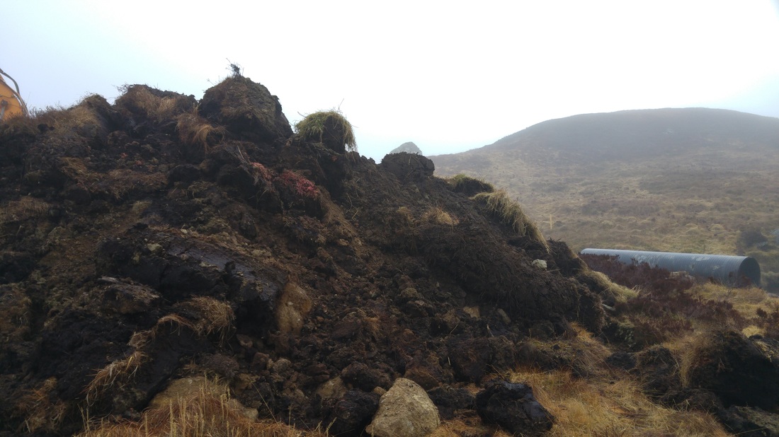
Ye shall not pass !!
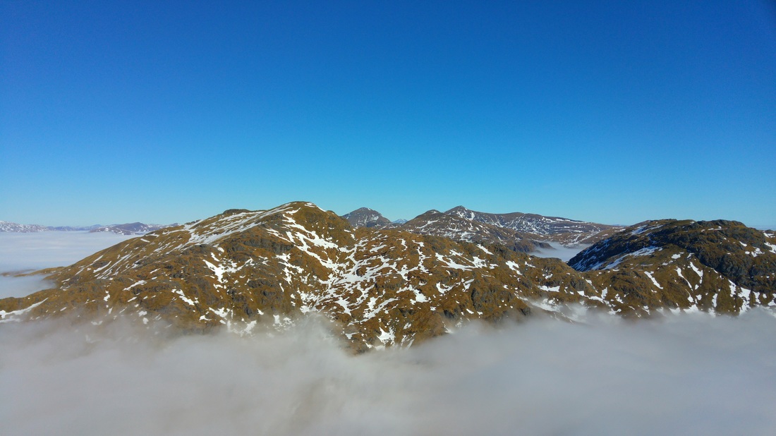
Heavy machinery was busy constructing a road through the moorland, I'm guessing wind farm ? but couldn't say for sure. A slight detour around the pile of mud and we were soon back on our way heading towards the Lochan Beinn Chabhair where we were to leave the burn and head towards the rugged ridge just west of Meall nan Tarmachan. I'm sure in clear conditions the lochan would make a lovely view but we could barely make it out in the poor visibility. By now we were around the 700m mark and despite a few rare and fleeting glimpses of the sun trying to burn through the cloud, I was starting to think that any chance of a clear summit was diminishing with every step. We continued on the path which winds it's way along the ridge through rocky outcrops and includes a couple of 'false summits' to further drain the energy from the legs. Suddenly, much like when a drifting, shipwrecked sailor spots land, an excited cry went up. "Look, blue sky !!" Sure enough, through the slowly drifting clag, a faint hue of sky blue could be seen. What an instant energy boost that gives you and soon the thigh burning initial ascent and energy sapping trudge through heathery, boggy moorland becomes a distant memory. With only a few more metres of ascent it was like someone had decided to finally turn the 'big light' on. Almost instantaneously we went from grey, dank and cool conditions to simply WOW. I don't have the vocabulary to do the views or the emotions they generated justice. I immediately took the phone from my pocket and snapped exactly what my eyes were first greeted with on our exit from the clouds. In this instance I think it would be best to let the photo do the talking !
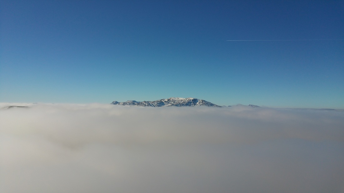
2 hours of damp grey nothingness and then WOW
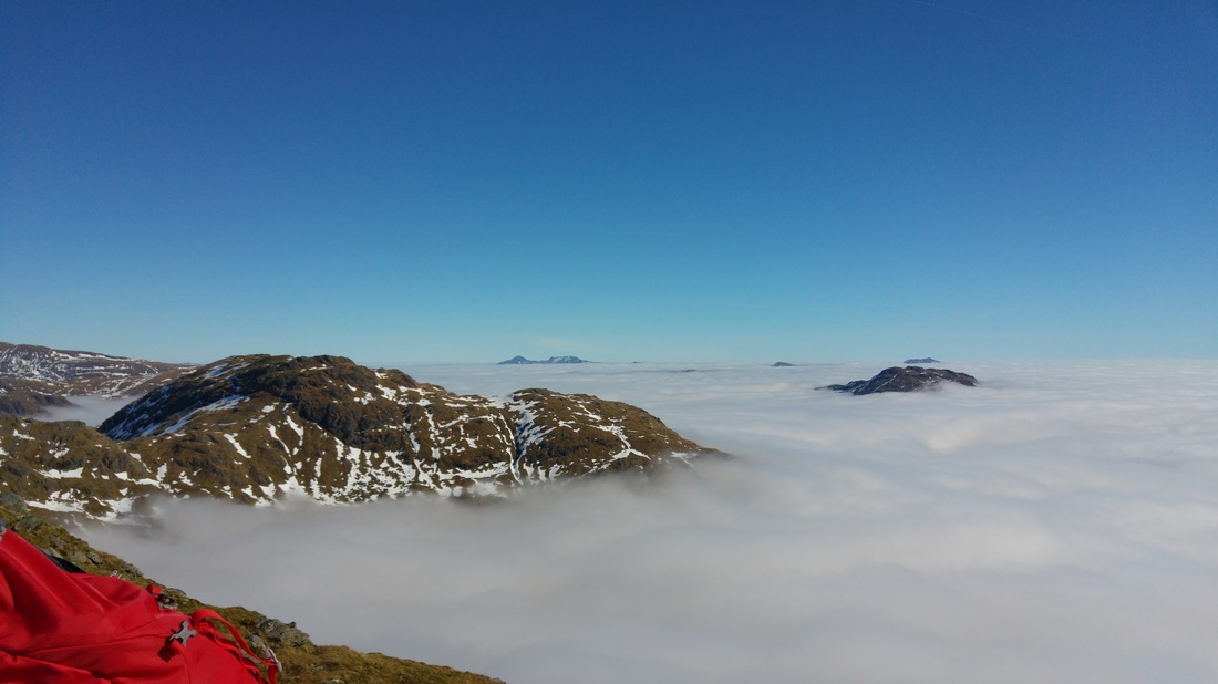
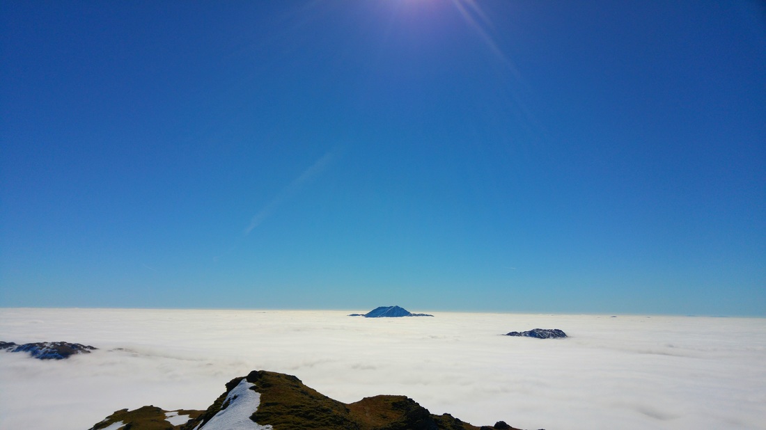
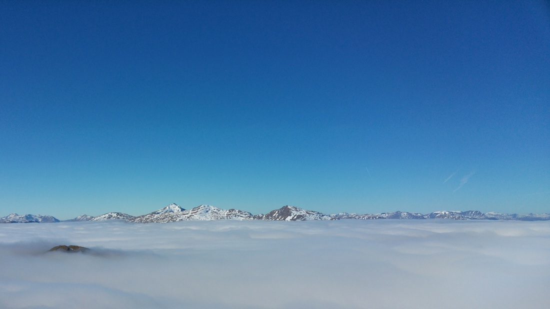
I have been lucky enough to experience a couple of cloud inversions but nothing as extensive and beautiful as this. The views in all directions as we climbed the last 100m or so to the summit were simply astounding. We reached the summit around 12.30 and quickly found a sheltered spot out of the cold, if slight, northerly breeze, just below the summit cairn. It was crazy to think that all over the country people were going about their daily business in cold, grey and generally miserable conditions whilst high in the sky above them we were literally basking in bright, warm sunshine. The well earned 'ham piece' has never tasted so good. I genuinely doubt there can be many cafes or restaurants around the world that could offer such a stunning panorama as you dined. With jaw dropping views in all directions it was a real struggle to even consider the thought of dragging ourselves away to begin the descent back into the cold and the gloom below.
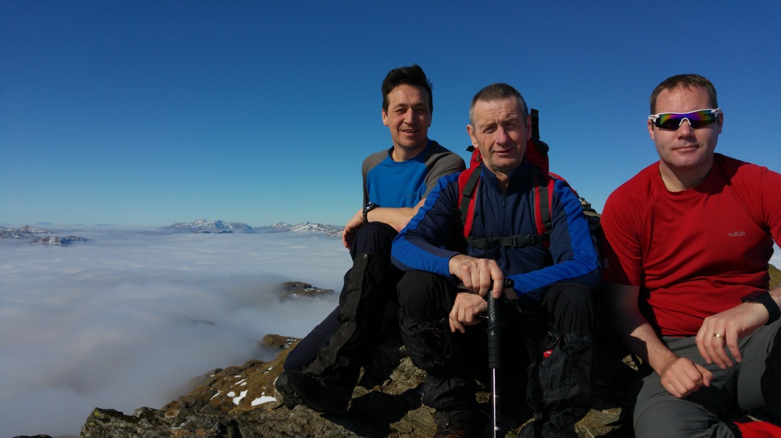
Nice to have company in the summit selfie for a change !
NE to An Caisteal & Beinn A'Chroin
East to Ben Vorlich & Stuc A'Chroin in the distance
South to Ben Lomond barely managing to keep her summit 'afloat' !
NW to towards Ben Lui and company
With heavy hearts it was time to head for home. As I soaked in the views for the last time the realisation hit that as our descent route retraced the ascent in reverse, it meant my knees would have to endure the steep, rocky path down to the campsite, I could hear them screaming out in disgust already ! As expected we were soon back in the cloud and 'head down marching' as best we could through the moorland back towards the Beinn Glas burn. I always struggle a bit on descents and those last couple of 100 metres down to the campsite were indeed a killer, however, we were safely back at the Drovers car park in just over 6 and a half hours, knackered and elated in equal measure. Number 62 done, and in the bag in style.
 RSS Feed
